What is GIS?
Geographical Information Systems (GIS) relate to the storage, management and manipulation of spatial or geographic data.
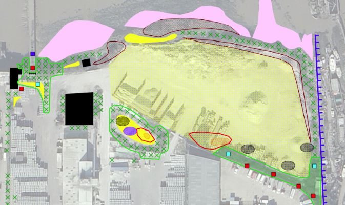
This tool is a valuable resource when it comes to displaying spatial data over base maps or aerial imagery. For example, EcoNorth uses this tool extensively when mapping habitat extent and the location of protected and notable species in relation to a particular site.
When do I need to get in touch?
If you require data to be collected on site, or if you have data that you would like to be digitised, manipulated or modelled, simply get in touch with us and we can determine your requirements and provide a quote.
In addition, through our collaborators we also offer high resolution surveys from aircraft that can be organised into GIS data that can be displayed or manipulated further to illustrate land coverage or habitats present (it is particularly useful when using the high quality aerial images provided by HiDef).
How can EcoNorth Help Me?
We can collect data, either in the field or from an existing database, digitise and model/manipulate it to illustrate a range of useful outcomes for your project. Typical data sets include topographic, ecological, land use and demographic data which can be used for presentations and inclusion in a range of reports. EcoNorth staff are trained to use MapInfo and QGIS (software which can export data in files that will support most GIS packages, including ArcGIS and QGIS).
Services we offer include:
- Collection of baseline data either in the field or from Local Authorities / Government Agencies.
- Environmental mapping to illustrate habitat extent, or protected / notable species locations based on ground truthing, aerial imagery and ecological data.
- High resolution image capture, processing and manipulation through our collaborators.
- Risk mapping to illustrate predications on levels of impact on ecological receptors, using specific modelling techniques, ie predicted impact of a housing development on badger sett locations.
- Site selection, where if you are a developer, you can pinpoint the most suitable area to build, with the least impact to the local ecology / environment.
- Predicted land use changes over time using demographic and environmental data.
Ask an Ecologist

Ecologist
I joined EcoNorth as an Assistant Ecologist in October 2021, following a period of subcontracting on bat surveys and providing the team with extra support during especially busy times over the summer, and was subsequently promoted to Ecologist in June 2023. Before that, I read Geography BSc at Northumbria University (2016-2019) and graduated from my …
Continue reading “Alex Douglas BSc (Hons) MSc”
Ask a question
EcoBlog

The 12 Days of Robin Facts
No CommentsDay 9: An American robin isn’t a robin at all, but a migratory songbird of the true thrush genus.